The Hidden History of Lyonsville Congregational Church: Underground Railroad, Pioneer Women, and Prairie Roots in Indian Head Park

The Lyonsville Congregational Church, located at Joliet and Wolf Roads in what is now Indian Head Park, Illinois, is the oldest Congregational church in Cook County. Originally founded in 1843 as the Congregational Church of Flagg Creek by 18 pioneer families, it was later renamed Lyonsville when the local post office changed its name.

In its earliest days, before any dedicated building existed, the congregation met in private homes of its members. Local tradition holds that one of those homes belonged to Deacon Rufus Brown, whose house served as a stop on the Underground Railroad. Freedom seekers (escaped enslaved people) were reportedly sheltered in Brown’s home near the church during the Civil War era. Because helping freedom seekers was illegal under the Fugitive Slave laws, these activities were kept secret, which is why much of the history survives as local lore passed down through families and the Flagg Creek Heritage Society.

The church’s first dedicated building was a log schoolhouse — the very first public school in the township — built on the opposite side of Joliet Road from the current church location. The congregation used this log schoolhouse for worship services for about 16 years. A single Scottish immigrant woman named Mary (May) McNaughton served as the first teacher in that log schoolhouse. Local historians still highlight how remarkable it was for a single woman in the 1840s frontier to take on such a visible public role. The schoolhouse effectively became the first “log-cabin church.” Mary McNaughton later married into the Vial family, further tying her into the founding community.

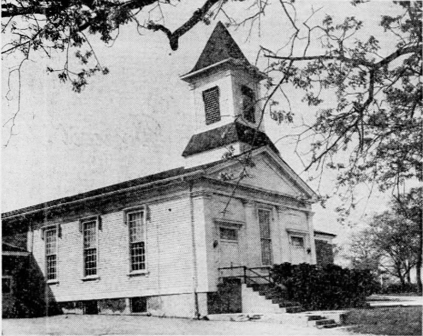
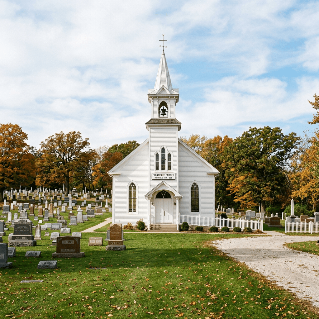
In 1858, the congregation erected a wooden chapel at the present location (southeast corner of Joliet and Wolf Roads) for approximately $1,800. The building features classic New England meetinghouse architecture and has remained in continuous service ever since, with various repairs and improvements over the decades.

During the Civil War, the 1858 church building served as a recruiting station for Union Army volunteers. Many local men from the congregation enlisted there.

The Pioneer Families

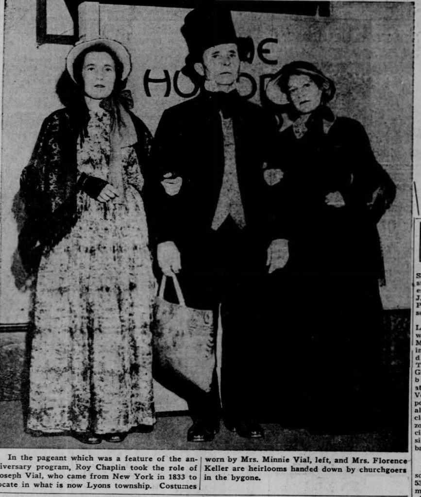
A 1943 newspaper article marking the church’s centennial highlights several key founding families:

  • The Vial (sometimes spelled Bial) family: Joseph Vial arrived in the community in 1833 when there were only two houses in Lyons Township. Robert Vial, a charter member, lived in the neighborhood for 87 years and died in 1921 at age 97. R.C. Vial and his sister lived next door to each other on the original Vial homestead.
  • The Craigmile family: More than fifty Craigmiles have been members over the years. When they arrived in 1843, they brought letters of transfer directly from a church in Scotland. Descendants Esther Craigmile and Edna Craigmile lived in Western Springs.
  • Other early families mentioned include Carrington, Cook, Ward, Derland (or Darling), Evans, Grover, and Polk.

Before the Burlington Railroad was built, Lyonsville was poised to become the main trading center for Lyons Township. Stagecoaches ran along Plainfield Road and Joliet Road, and the area functioned as a church and school hub in the open prairie landscape.

Landscape and Setting

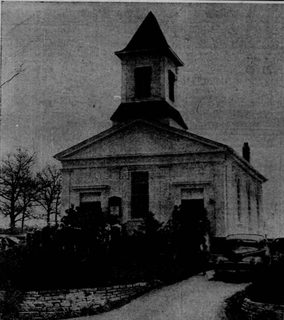
The area that became Indian Head Park was originally tallgrass prairie. It was later converted to farmland. All the trees visible today — including those around the church at Joliet and Wolf — are not original. They were either planted by residents over the last 100+ years or are invasive species that moved in after the prairie was settled. In 1943, the church stood as a picturesque wooden landmark in Flagg Creek Valley, about 17 miles southwest of Chicago’s Loop, almost completely surrounded by golf greens of the Flagg Creek Golf Course.

Connection to Western Springs

The Lyonsville church also played a key role in founding another congregation. Reverend J.C. Armstrong of Lyonsville began holding Sunday afternoon preaching services in a schoolhouse on Chestnut Street in Western Springs. This led to the 1883 formation of the Western Springs Christian Association, the direct predecessor of the Western Springs Congregational Church. Much credit for the start of that church is given to Lyonsville and Rev. Armstrong.

The Map and Local Historian

Local historian Sharon L. Comstock, Ph.D. (author of the 2015 book Burr Ridge in Arcadia Publishing’s Images of America series) has done extensive research on Lyonsville and abolitionism in early Chicago. She serves as a Trustee of the Lyonsville Cemetery Association and works closely with the Flagg Creek Heritage Society. According to her, she has located a historical map showing the exact former location of Deacon Rufus Brown’s house. She expressed interest in further conversation after reviewing public profiles.

The church continues to stand today as a physical link to this rich pioneer, abolitionist, and community history.

Chicagoland area Night Skies.

With an R6m2 and 24-70 lens, I shot this picture, but had to ask Gemini what it was. Here is what I captured in the pot of the Ursa Major constellation.

Do you believe what Gemini said? … Gemini said, “That is an incredible capture! You didn’t catch a street light flare, nor is it a permanent deep-space nebula.

What you caught is a rare, highly localized atmospheric optical phenomenon called a circumhorizontal arc (or a closely related ice-crystal halo variant like a supralateral arc), lit up by a bright light source.

Here is exactly what is happening in your photo:

Why It Looks Like a Rainbow in the Night Sky

Even though it has the full spectrum of colors, it isn’t a traditional rainbow. Rainbows require liquid raindrops and a light source directly behind your back.

Instead, this is caused by light refraction through ice crystals. High up in the upper troposphere—even on nights that seem perfectly clear to the naked eye—there are thin, wispy veils of cirrus clouds made entirely of microscopic, hexagonal plate-shaped ice crystals.

When a bright light passes through these precisely oriented crystals, they act like millions of tiny glass prisms. The light enters the top face of the crystal and exits a side face, bending (refracting) and separating into distinct red, orange, green, and blue wavelengths.

Why is it next to the Big Dipper?

Because you shot high up into the northern sky near the Big Dipper, the geometry tells us exactly how this happened:

  • The “Rainbow” Arc: The ice crystals were perfectly angled at that specific patch of sky to split the light toward your camera lens.
  • The Long Star Trails: The slight elongation of the background stars indicates you used a long exposure (likely several seconds or more).

Because your camera sensor was gathering light over a longer period, it picked up the vivid, saturated colors of this icy refraction that might have looked like a faint, pale smear of cloud to your naked eye.

Could it be something else?

Given the recent solar activity over the past couple of weeks, high-altitude atmospheric anomalies have been common, but the sharp, distinct separation of colors into a perfect “prism” band points directly to ice crystal refraction rather than an auroral arc (which typically glows in specific green, red, or purple bands without a clean rainbow gradient).

It’s an incredibly lucky framing to get a crisp, colorful atmospheric prism cutting right through a field of stars!”

The Secret History of Chicago’s “Town of Lake”

Discrimination in 1800s Chicago

Ever look at an old newspaper and realize history is just a bunch of people shouting at each other to get it together?

​I found this Polish newspaper clipping from 1912, right here in Chicago. It’s a fiery editorial written by an immigrant who is absolutely furious at his own community. He feels that the Bohemian and Irish have too much pull, leaving the majority Polish community feeling like second-class citizens.

The article is from a place called the “Town of Lake.” If you know Chicago history, that’s the massive independent township annexed into the South Side back in 1889—right where the legendary Union Stock Yards were. Today, the address 4840 South Paulina is the heart of the Back of the Yards neighborhood.

​By 1912, this area was a brutal, industrial melting pot. It’s the exact setting of Upton Sinclair’s famous book, The Jungle, which exposed the meatpacking industry through the eyes of newly arrived Lithuanian immigrants.

But this Polish writer is mad. Why? Because the newer immigrants—the Poles and the Lithuanians doing the hardest labor in the stockyards—felt like second-class citizens. They were completely shut out of power.

​The author screams, “What kind of aldermen do we have? An Irishman and a Czech!” He slams his fellow Poles for being “naive” and avoiding their own people. He says they’re flocking to Czech banks, buying from German warehouses, and paying fat legal fees to Irish and German lawyers right under their noses, instead of supporting Polish businesses.

He ends the piece with a massive battle cry: “Solidarity, and once again, solidarity!” It’s a wild look at how these neighborhood lines were drawn, the intense rivalries between the Irish, Czechs, Poles, and Lithuanians, and the grind of trying to make it in Chicago over a century ago.

This area is covered between today’s 39th Street and 87th Street, from State Street to near Cicero Avenue (other sources say to Western Avenue, and Wikipedia says Pulaski.

Auburn Gresham, Englewood, and other neighborhoods are standing in an area that had ethnic diversity that discriminated against one another. There was ethnic and family unity in one aspect of the area, but then there was lawlessness and prejudice towards other cultures that spoke different languages and waved different flags.

In 1891, on April 1st, towards the west side, Rev. Hensen(called sensationalist Hensen) spoke at a church, calling the bars and drunks there to be similar to vampires sucking the blood out of politics and civility. A lot of people pushed votes at saloons in those days. He called them hell-holes. He says “that they hang the anarchist who throws bombs, but at the same time elect the same type of anarchist that comes from those hell holes to become an alderman or a saloon keeper. He said, “that all the good conspiracies against law, good order, peaceful social relations, and good municipal administrations are hatched in the low saloons”.

When Elmer Washburn was running things in “Town of Lake”, there were about 500 saloons in the vicinity. Elmer had some power similar to that of a Mayor in the “Town of Lake”. People criticized him for letting the drunks do whatever they wanted to do. The saloons were open 7 days a week, and many people felt ill about that, since Sunday was a holy day for them, for family, not for a saloon. The saloons would stay open all night as long as there were customers, the place stayed open. Just imagine the type of community where everyone got together at their favorite saloons, and where fights, drunkenness, and houses of ill repute were part of the nightly fashion.

Years before the wild times in the Town of Lake, Mayor Roche in Chicago drove out a lot of gamblers and drunks. A lot of those people came to the Town of Lake. What started out as a peaceful community of German and Dutch truck farmers turned into some wild times by the end of the 19th century.

The Roseland Chicago Underground Railroad


Cornelius Kuyper, John Ton, and others: The Dutch Founders of Roseland Who Helped Build Chicago’s Black History

In 1849, a small group of Dutch immigrants arrived in what is now the Roseland neighborhood on Chicago’s far South Side. Among the original nine families were two men whose stories still deserve to be remembered today: Cornelius Kuyper and John Ton.

The Early Days on High Prairie

When the Dutch settlers first arrived, the area was known as High Prairie — higher, drier land compared to the swampy “Low Prairie” along the Little Calumet River to the south. According to the March 4, 1900 Chicago Tribune article “How Chicago’s Suburbs Were Planted and Named,” Cornelius Kuyper was one of the very first to build on High Prairie. He constructed the first brick house in the area at what is now 103rd Street and Michigan Avenue. That house also served as the first store in the settlement.

Right next door to him settled Gorus Vanderside. The newspaper notes that after Kuyper built his brick home, Vanderside moved in beside him, helping establish the early community.

John Ton, another of the original nine Dutch settlers, initially farmed farther south on land owned by the Dalton brothers near the Little Calumet River. Over time, he too became deeply connected to the Roseland area.

Why “Roseland”?

The land was originally called High Prairie, but as the Chicago Tribune explained in 1900, a real estate agent working to sell lots and houses near the new Pullman factory didn’t like the plain name. He came up with “Roseland” because it sounded beautiful and attractive to potential buyers. The name stuck, and by the turn of the century, the community proudly called itself Roseland.

Cornelius Kuyper: Storekeeper, Constable, and Underground Railroad Helper

Kuyper quickly became a central figure. He:

  • Ran the first general store (out of his own home)
  • Served as township constable
  • Opened his brick house as a station on the Underground Railroad

Together with John Ton, he helped hide freedom seekers escaping slavery and moved them northward toward safety, often in the direction of Holland, Michigan.

John Ton: Fellow Pioneer and Freedom Fighter

John Ton is consistently named alongside Kuyper in the old newspapers as one of the founders of Roseland. Later in life (around 1893), he built a handsome Dutch Victorian home at 316 West 103rd Street.

Their Legacy in the Newspapers

The late 19th and early 20th century Chicago papers celebrated these Dutch pioneers:

  • The Chicago Chronicle (Dec. 22, 1895) ran a feature on “Worthy Dutch Citizens” with group sketches and portraits.
  • Another Chronicle piece (March 14, 1897) highlighted the Dutch community’s growth, homes, and businesses.
  • The Chicago Tribune (March 4, 1900) gave detailed profiles and portraits of Kuyper, Ton, and others, preserving their stories for future generations.

These articles show that Kuyper and Ton were not just farmers — they were community builders, merchants, and quiet heroes of the abolitionist movement.

Why This History Matters Today

Roseland’s story is Chicago’s story: Dutch immigrants working alongside others to shape a new community, while also playing a role in one of America’s most important moral struggles — the fight against slavery.

Many people today have never heard these names. That’s why videos and articles like this one are so important.

Cornelius Kuyper and John Ton helped plant the seeds — literally and figuratively — for what became Roseland. Their brick houses, their stores, their courage on the Underground Railroad, and their role in naming and growing the neighborhood deserve to be remembered.

Sources & Images

  • Chicago Tribune, March 4, 1900 (“How Chicago’s Suburbs Were Planted and Named” and “Two of the Founders of Roseland”)
  • Chicago Chronicle, Dec. 22, 1895 and March 14, 1897
  • Chicago Public Library Calumet Region Community Collection

Roseland neighborhood Chicago

I was looking up this neighborhood for a couple days. Initially I was looking into John Ton and the underground railroad. I had no idea that the underground railroad was once in the area. There’s 178 neighborhoods in Chicago and I’m sure there’s something really cool in every single neighborhood. Roseland is actually a community area; a larger neighborhood with little neighborhoods inside. So I Doug into historical documents for hours reading tons of articles and shifting through articles that seemed even have relevant until I moved on to the next one. As always I make sketches until something more tangible comes along, and I created the Roseland video with a big focus on John ton. Before uploading I did more research and discovered an article that talked about the tone family being in Calumet park. I was so pissed. Now I had to shift neighborhoods or just give up on the whole idea. This was around midnight. I don’t like screwing up my sleep schedule. I rather wake up and start working at 4:00 in the morning then staying up all night until 4:00 in the morning. The first thing out of bed I did was research more and I discovered that John was in the area initially. Then I found old 19th century articles about Cornelius Kuyper, who was another Dutch immigrant who participated in the freedom of black slaves at the time.

When the Dutch first came, they couldn’t speak English so they got a translator to show them around. They bought highland area between 107th and 111th from Michigan Avenue and west for $5 an acre. Then after that they bought another 80 acres north of that which was split up between a some few Dutchmen including Kuyper. They had ox bring lumber from Chicago to build the houses, the progress was slow. A. de Kake was the carpenter in the group leading the team. They weren’t able to find other Carpenters to work, so the Dutch immigrants built their own houses with the help of de Kake. And once they build their houses they needed work so they employed their selves as farmers and got to work on the soil. They used oxen to plow and make things happen. Josh Billings said “he who by the plow would thrive, must no two-forty hosses drive, but worry the ground to and fro, with horned critters that skasely seem to go”.

The Roseland Dutch immigrants did thrive with their markets by doing gardening, stock raising, and dairy farms. The men from Holland worked very hard to create this neighborhood and then the produce from it.

At the time, Chicago was described as a straggling village. Not far from them was blue Island that held only a few houses. There was a couple houses in South Englewood at the time. Riverdale had a few houses and now High Prairie which was later called Roseland had only a few houses in the 1850s.

They hunted a lot of goose and duck and pigeon. In Spring and fall, the skies would still fill with fowl creating dark skies for many hours. This was a typical site throughout early America. Infrastructure housing and streets and parking lots killed most of the wildlife habitation and currently the skies are mostly clear of many birds like they had a couple hundred years ago. It would make pigeon soup and other dishes from the birds. They would utilize the feathers for various things. It was hard to live in Chicago at the time because the wages were anywhere from 30 cents to a dollar a day, so a lot of these Dutchman turned to the farms and hunting. Life and transportation wasn’t very easy back then so a lot of young people took social rides two-headed pathway to Chicago behind a yoke of oxen.

Life was hard for the dutchman. But they’re consistent prevalence soon push them out of their hardships and they eventually open the store. Kuyper open the first store in roseland. He opened it in his house. Part of his house was the first store. It was open between 1850 and 1854. By the time more Dutch immigrants came to the area in 1856, the area of what we now know is Roseland have been doing quite decently.

1850s Roseland neighborhood of Chicago

N Dalenberg and Cornella Gouwen were the first people of the neighborhood to get married. George de Young what’s the first child born in the area now known as roseland. George Dion didn’t live very long so he was also the first death and buried of the roseland community. There wasn’t a lot of people in the beginning. The first church had only 18 members. The women set and chairs of the church and the men sit on benches.

110th Street was the first mercantile business from a Chicago man who helped Kuyper run the business, which became a general store there on 110th Street which was then called Thornton street. Things started to happen in the Rose land area. They moved the post office from Calumet to the Roseland community and called it the Hope post office. And on 107th Street, the first school opened up in the back of the church. Peter de Young was the teacher there. They taught Dutch mannerisms, principles, and studies. But some time in the 1850s about 5 years after the other school began, the community decided to send the children to Gardner School to learn English and to learn in the English language. Gardner School was a log house.

Georgia Vandersyde and John Ton made the first map plat of the area. The values of the building started to rise and Chicago then annexed Roseland in the year 1890.

John Ton, Kuyper, and others participated in the underground railroad. They were somewhat successful people at the time. They were some of the first people to live in the Roseland area and part of the people that made the neighborhood to what it became. They shared some of her their success by helping the slaves find freedom and be safe from the hunters whose ambition sprang for a reward to capture runaway slaves.

J. Ton had hundreds of descendants that would have annual meetings and family reunions well into the 20th century. Some of the histories stayed with the family, but most of the stories have disappeared with those family members.

This is only a fraction of the history of the Roseland neighborhood in Chicago.